Get every episode summarized
Each time Weather With Enthusiasm ! publishes, we email you a written briefing from the transcript — the topics, who appeared, and any specific claims, with the ad reads skipped.
Email me new episodesFree for 3 shows. No card needed.
About this episode
“It's not just electric, it's Toyota Electric. And during Toyota's easy-to-toys sales event, going electric is easier than ever. Right now, save instantly on a new Toyota EV with special incentive programs for first-time EV buyers and prior EV owners.”From the transcript
- 00:00 - 01:01: Introduction, Southern California heat wave, Midwest storm system, Pacific and Gulf moisture, unusual high dew points in the 70s in September/October.
- 01:01 - 02:05: National Weather Service confirmation of high dew points, comparison to Chicago area rainfall and East Coast Sukkos weather.
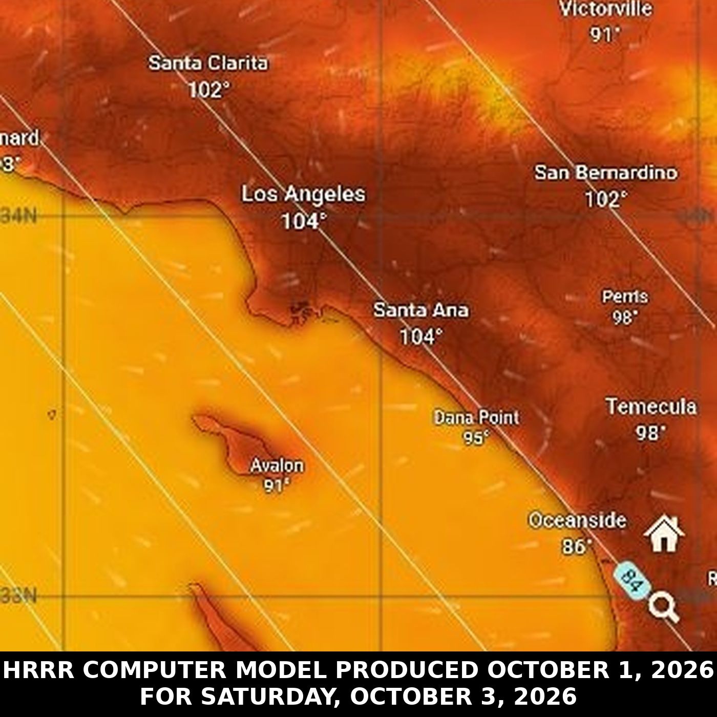
- 02:05 - 04:04: Focus on the "very impressive" Southern California heat, extreme heat warning issued until October 8th, details of temperatures (90s at coast, 105 in valleys) and impact.
- 04:04 - 05:07: Discussion of the unprecedented nature of the heat forecast for October, mention of the forecast discussion details.
- 05:07 - 06:08: Official National Weather Service statement on the long-lasting heat wave due to a strong high-pressure system, weakening pressure gradients, and non-traditional Santa Ana winds.
- 06:08 - 07:09: Expected temperatures (102-107 in valleys, 99-103 downtown LA, 90-98 coastal), 15-20 degrees above normal.
- 07:09 - 08:12: Heat advisories for central/northern Santa Barbara counties, potential for even hotter weather and record-breaking temperatures later next week.
- 08:12 - 09:14: Speaker's thoughts on AI-generated content vs. human passion in weather forecasting, introduction to "Weather Across America" podcast.
- 09:14 - 10:23: Reiterating the significance of the California heat, Midwest cooling trend (temperatures dropping to 40s/30s), and the re-emergence of a "heat dome."
- 10:23 - 11:29: Explanation of how to visualize the heat dome on windy.com (500 HPA/MB, geopotential height isolines), its persistence over Los Angeles.
- 11:29 - 12:31: The heat dome shifting towards Phoenix, questioning if it's the same long-lasting dome from August, its impact on hurricane paths (redirecting Pacific hurricanes).
- 12:31 - 13:32: The heat dome's effect on Atlantic hurricanes, its national impact, and the expected jet stream dip outside the heat zone affecting the Midwest.
- 13:32 - 14:34: European computer model forecast for Minnesota temperatures (60s, 50s, 70s), lack of significant cold air.
- 14:34 - 15:36: Polar vortex and cold air location (Canada, upper atmosphere), potential for cold air in mid-month for upper Midwest, discrepancy with surface temperatures.
- 15:36 - 16:39: Encouragement to listen to AI episodes for more in-depth coverage, good wishes for Hoshana Rabba and a beautiful, cooler weekend in Chicago.
- #WeatherForecast
- #CaliforniaHeatwave
- #ExtremeHeat
- #MidwestWeather
- #DewPoint
- #OctoberHeat
- #ClimateChange
- #NationalWeatherService
- #HeatDome
- #HurricaneSeason
- #ElNino
- #WeatherAnomalies
- #LosAngelesWeather
- #ChicagoWeather
- #JetStream
- #WeatherPatterns
- #AuthenticWeather
- #WeatherDiscussion
- #HoshanaRabba
- #WeatherEnthusiasm
Become a supporter of this podcast: https://www.spreaker.com/podcast/weather-with-enthusiasm--4911017/support.
Not affiliated with any government agency or academic institution. Presented for educational and entertainment purposes — with meaning.
Support the show — exclusive bonus episodes available to subscribers for just $2/month at spreaker.com/organization/kol-simcha
Get every episode summarized
Each time Weather With Enthusiasm ! publishes, we email you a written briefing from the transcript — the topics, who appeared, and any specific claims, with the ad reads skipped.
Email me new episodesFree for 3 shows. No card needed.
Hosts & guests
Transcript ready
315 searchable segments. Every word is indexed and playable.
Full transcript
Weather With Enthusiasm ! — Extreme Heat Redevelops in the U.S. October 2026. Machine-transcribed; use the interactive transcript above to jump the player to any line.
It's not just electric, it's Toyota Electric. And during Toyota's easy-to-toys sales event, going electric is easier than ever. Right now, save instantly on a new Toyota EV with special incentive programs for first-time EV buyers and prior EV owners. Choose the sleek Beasy, the adventurous Beasy Windland or the Sporty CHR. But don't wait! These special savings won't last. We make it easy. Toyota, let's go places! You're listening to Weather with Enthusiast. Good evening, it's Oshana Rabo. I want to wish everybody a good to know it. Our top story tonight here on the Weather Map is without a doubt, is the heat in Southern California. Perhaps there's people who have missed this due to a phenomenal storm system that's taking place here in the Midwest. From the remnants of the various hurricanes, bringing in Pacific moisture and the Gulf of Mexico or Gulf of America moisture
that's streaming northward here into the Midwest, bringing heavy rain. So we do have a second remarkable thing. I already said a second remarkable thing, so we can move on to a third. But I don't know, you know, the third, really, it's the dew point in the 70s once again. A month ago, dew points in the 70s was something phenomenal. It's September, dew points in the 70s. The corn crop is already, you know, it's the sweat of the corn crop sweat were four to six weeks after the peak. That was the beginning of September. Once again, the national weather service tells us tonight dew points are going into the low 70s in Southeast Iowa. We don't even have temperatures that hot in many areas. So it's very hard to get dew points in the 70s. Not just this time of the year, but when you have temperatures that are not in the 90s, temperatures are not even in the 80s. And you can get dew points into the low 70s. This is super impressive stuff.
That's what's been going on here in the Midwest. But I think really some of the highlights are just the tremendous heavy rainfall accumulations of one to three inches expected in parts of the Chicago area. Kind of like a 180 from what was going on in the beginning of Succus, where we had that one to three inches, even higher amounts off on the east coast, which kind of ruined perhaps the first couple days of Succus, at least nothing's ever ruined, but regarding eating in the Succus. So we have that right now here in the Midwest. I think the east coast is enjoying sunny skies and beautiful weather. Let's go back to the west coast because this is something very impressive. One of the things that makes it so impressive is the fact that there's no end to the heat inside. Let me read you something. This comes from the Los Angeles National Weather Service. First of all, we have an extreme heat warning. In fact, October 1st, all the way. This is like drum roll material. Do I have a drum roll? This is drum roll material. And if we have a drum roll, we're definitely only going to do it
because I have to tell you when it goes all the way. All the way eight days until October 8th, 8pm. Totally amazing. I believe this is not a joke. Some people think because there's sound effects, there's some kind of a joke. There's no joke over here. This is seriously happening. This is unbelievable stuff. It was issue 12-17pm, Civic Daylight time. It's in effect until October 8th, 8 o'clock PM, Civic Daylight time. This is by the Los Angeles National Weather Service, Oxygen, California. Dangerously hot conditions with temperatures up to 90 at the coast and 105 in the valleys. 105 in the valleys. This is for the coast and the valleys of Los Angeles and Ventura counties.
10am Friday, all the way till 8pm, Civic Daylight time Thursday. Impact, heat-related illnesses, increased significantly during extreme heat events. Some additional details, very hot temperatures are likely to continue into the second week of October. This is something, the next five words or seven words is something that you never would think you would ever read in a forecast discussion in October for Los Angeles. This is what it says, possibly requiring an extension of this product, the product. This is what is said when you go into Texas in June or July, we don't know when the heat's going to end. We don't know. We're holding right now in October. Now, what's bringing the heat? So for that, we go to the amazing forecast discussion. And I would love to share this with everyone. This was issued 5.35pm, October 1st. This is for them. It's probably shortly before the beginning of our little Yantifiro, Shana Rabo.
A major and long-lasting heat wave will begin Friday and last through all of next week, at least, with dangerously hot temperatures. This is going to have tremendous impacts, by the way, on the hurricane season, possibly positive impacts. We're going to talk about that in just a second. I just want to get through the forecast discussion here. Here we go. Very dangerous and long-lasting heat wave, Friday through at least next week, and likely extending into the second week of October. That's from the official National Weather Service forecast office of Los Angeles. They say the following, no significant changes to the short or long-term forecast. A dangerous heat wave will begin Friday and last through all of east next week, as a strong high pressure system sets up over the eastern Pacific and west coasts. Pressure grading enter already starting to weaken today. That means the winds are calming down, and that trend will continue to Saturday morning. That shop is morning, that Shmini at Zeris morning, resulting in offshore gradients to the east, and north, in the minus two to minus four range.
So while this is an offshore scenario in October, it's not a traditional Santa Ana, as the upper support is not sufficient for persistent gusty winds. Though there will be brief periods of some sub-advisory level north to northeast winds at times. However, in typical Santa Ana fashion, this heat wave will include the beaches at least south of Port Conception. Temperatures will ramp up quickly, Friday by five to ten degrees and peak on Saturday. Though the word peak, and I just lost it, but the word peak is misleading because day-to-day high temps will likely not change much, at least through early next week. During the heat wave, warmer valley highs are expected to be 102 to 107. Downtown Los Angeles 99 to 103 and coastal areas. From Santa Barbara to Los Angeles 90 to 98, these are 15 to 20 degrees above normal.
It will be warming in... Now, S-L-O. I should know what that means. I don't know what that means. In northern Santa Barbara counties, it's going to be warming in Santa... That's probably Santa L-O. I don't know. There's probably people listening to this who do know. So, in northern Santa Barbara counties as well, but delayed by a day, by the weekend, expecting highs away from the beaches to the low to mid-90s, and lower 100s in the interior. Heat advisories have been issued to these areas Saturday and Sunday. These may need to be extended in certain areas next week, but models have been showing just enough cooling early next week to allow the advisories to drop off. Here we go to the long term Monday through Thursday of next week. This period will feel a lot like this coming weekend, though there are still some model solutions indicating a little more upper-level northeast wind support,
and subsequently even hotter temperatures. This would be in the Wednesday to Friday period, so there is the potential for even hotter weather later next week with a better chance of breaking daily temperature records. Longer-range models are starting to at least hint at some cooling next weekend. We have... Okay, so what we have to speak about over here... This is something that just popped up out of the blue, really. To me, that's what it feels like. It looks like I'm actually out of time. So, I'm out of time. What we did is we have the AI-generated voices on many other segments. There's another podcast that I'm doing. It's called Weather Across America. That one's really completely AI. It's not like the amazing weather with enthusiasm where you get to hear, for the most part, you get to hear an actual human whose passion is weather what could be more authentic than that.
Any hobby, any interest that someone has, if I want to listen to any subject, the best person I always think is someone who's passionate about the subject. That outbeats any AI voice. Nonetheless, the other podcast, whether across America, has the AI. It does have certain advantages that we don't have. It really covers a lot. It goes through all the cities. It goes through the Zmanim for those people who want to hear about the Zmanim. Okay, but here we have weather with enthusiasm. And up until April, we didn't have any AI. And I'm trying to move away from that for weather with enthusiasm again. The authenticity. That's the most remarkable part of the weather map, I think. That's without a doubt, it's the heat. We have a storm system here in the Midwest. It's going to be bringing our coldest weather. It's, you know, okay, fine. That's nice and remarkable. But you know, it's already October.
So it's about time that the colder weather comes. Temperatures are expected to drop into the 40s in the Chicago area of Friday night. We even have some computer models indicating that some of the colder spots could go down into the upper 30s. Before I go. Let me just show you or I can't I can't show you. But you know, unwindie.com. When you go to the various computer models, you'll see that there is once again that good old heat dome that sets itself up over in the Los Angeles. It's off the coast in this one. What's interesting about this one is that it's visible. You have to put, when you do is you put the temperature up at the 500, it will say HPA, that the same thing is 500MB. And then you put, you set the pressure for isolines of geopotential height. That's how you do it. And then you'll be able to see that there's actually tomorrow.
We already have some type of the heat dome over Los Angeles. Especially until you get 590 decimator heat dome. And this thing just stays around for a very long time. On Shab is it's still 590.7. So it's basically 591 already. When you head into Sunday. On Sunday, it looks like it's slightly harder to find, when you're looking on windy.com. But it becomes, oh, here we go. It looks like it's centered right over Phoenix, Arizona on Tuesday. It's still 590.6. You have to wonder, is this the same heat dome? Is this the same heat dome that's been going on since August? That's been moving back and forth. I totally wasn't paying attention to it because it wants the thing moved south of Houston.
And it's over with. Has this thing retrograded back to Phoenix? That's a question. It feels like it's the same heat dome. It's that thing that just sticks around once it's there. It sticks around for weeks. We're headed into the second month of October. We have a powerful alneño coming up. And regarding these hurricanes. So one of the things that I noticed is that when you have these heat domes you have a powerful, premutile high. So it directs the hurricanes elsewhere. So up until now, you know, the hurricanes have been just non-stop in the Pacific Ocean. We've had the heat dome really out east. It even covered St. Louis for a while. But it wasn't on the west. So that could have interfered with a lot of the hurricanes. It could be why it almost feels like there was a shortage in the Atlantic. You such a term. But in the Pacific it was just like they were all lined up.
But now that you have this out in the Pacific, so it'll be interesting to see what happens regarding this for the next two weeks. It's almost like you're safe. Things are going to go around this heat dome. And these things are going to impact the weather across the country. The whole country will be impacted by this. Just like the whole country was impacted by the heat dome back in September. What's likely going to happen is we're going to see a big dip in the jet stream just outside this area of intense heat. This is a stationary area of heat. We see a big dip in the jet stream right outside of that. And that could have strong impacts on the Chicago area or portions of the Midwest. We go and look at the temperatures. I'm putting it right now. Temperatures, we have the European computer model. And I'm just looking at up in Minnesota. We have central Minnesota. Okay, low 60s for low 60s on Sunday, mid to upper 50s.
Monday, temperatures warm up a lot on Tuesday. They go into the 70s. Back into the low 60s for Wednesday. And they have to see like. And it doesn't really look like we get that cold air. So you have to wonder. Until you get to Monday, even Monday, October 12th, it's hard to find. It really doesn't seem to be happening. That is the European computer model. But we know that there are consequences to these things. It impacts the whole country. Although right now, I don't really see it to see it. I don't seem to see it right now. Because it's dry over here too. So the polar vortex type stuff. That's all the way up at 78 degrees north latitude. Or today, let's say, the super bitter cold air in the upper atmosphere.
It's up at about 66 degrees north latitude. We're up at 71 degrees north latitude. You can see the really, really cold air is up in Canada. That's in the upper atmosphere. And the air seems to stay there. It seems to stay there. Just, there might be something hitting New England maybe for next week. Something else in northern Maine, maybe overshab is on the 10th. I'm just looking at the upper atmosphere, the 500mb level. And we do see some cold air possibly coming in the middle of the month. But even that stays in the upper Midwest. That's a far away from now. And when you look at the surface temperatures.
The surface temperatures don't seem to match it. So in any case, you're welcome to listen to the AI episodes which cover things a lot more in depth. And I wish everybody a Gamar Khassim Atowal. Have a Gavaldic Hoshana Rabo. There is a minhag tonight to stay up tonight. And then there's that Kabalistic thing with the moon, which I think there is an episode on that. A lot of people don't do that because it's very scary. And also there are some other issues with it as well. I'm having Yavin Yavin and then we go into a very beautiful weekend just cooler by the time he's at Chavis and Someday for here in Chicago. Okay, thank you for listening. I wish you all. It's not just electric. It's Toyota Electric. And during Toyota's Easy Choice sales event, going electric is easier than ever. Right now, save instantly on a new Toyota EV with special incentive programs for first time EV buyers and prior EV owners.
Choose the sleek Beasy, the adventurous Beasy, Woodland or the Sporty CHR. But don't wait! These special savings won't last. We make it easy. Toyota, let's go places.
More episodes
More from Weather With Enthusiasm !

Trailer For Podcast "Weather Across America" .
Weather With Enthusiasm !

5787- september 29th Sukkot Forecast, Zmanim, chol moeid activities, reminders
Weather With Enthusiasm !

Hurricane Polo & Flash Flooding as 90° Heat makes a run at St.Louis 9-29-26
Weather With Enthusiasm !
Some words of inspiration for our friends on the East Coast celebrating the Jewi...
Weather With Enthusiasm !